Why Pembrokeshire Is the Home of Coasteering
Coasteering was born here. The sport — defined as traversing a rocky coastline at sea level, swimming through channels, scrambling over rocks, and jumping off cliffs into deep water below — was first formalised on the sea cliffs of St David's Head in the mid-1980s. The Pembrokeshire coast offers conditions that exist almost nowhere else in Britain: clean Atlantic water, dramatic igneous and sedimentary rock formations, sheltered coves and deep-water cliff jumps all within walking distance of each other.
The National Park stretches for 186 miles of coastline, but only a fraction of it is suitable for guided coasteering. The best sections combine manageable sea swell, clear water depth, accessible put-in and exit points, and the natural features — arches, caves, channels, ledges — that make a route genuinely memorable. Below are the spots our guides return to again and again — starting with the south coast, where some of the finest and most varied coasteering on the planet begins just steps from Tenby Harbour.
"Pembrokeshire coasteering isn't just cliff jumping into water. It's full immersion in a landscape most people never see — the underside of the cliffs, the inside of the caves, the places the boats can't reach."
Tenby — St Catherine's Island Coasteer
Starting just 100 metres from Tenby Adventure's harbour HQ, the St Catherine's Island coasteer is one of the most distinctive routes in Pembrokeshire — and one of the least like anywhere else you'll coasteer in the world. This is a high-tide-only route, which means the experience depends entirely on the sea filling the limestone caves to their roof, creating conditions that are eerie, spectacular and unlike anything on the north coast.
The centrepiece is a network of intricate sea caves carved into the headland — including the pitch-dark tunnel known as the Worm, where you swim blind through complete darkness with the cave ceiling inches above the water, and the Crack, a barely-body-width fissure in the cliff that opens into a hidden chamber beyond. Strong tidal currents between the island and the mainland create a natural lazy river — surrender to the flow and you're swept through in seconds. This is an exploration coasteer first and foremost: fewer jumps, more discovery, and a genuine sense of venturing somewhere entirely off the tourist map. Book it at high tide. You won't forget it.
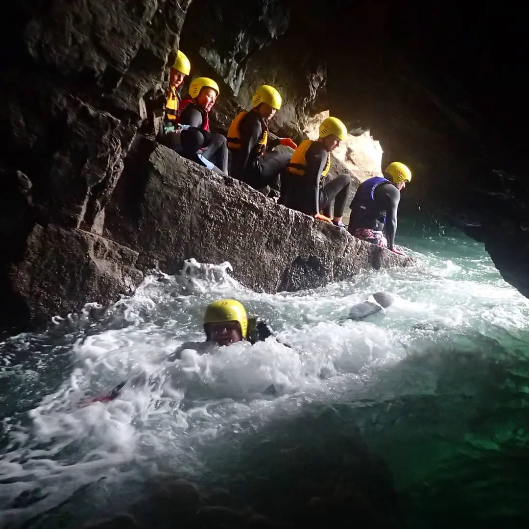 The cave systems around St Catherine’s Island — eerie, pitch-dark in places, and completely inaccessible except at high tide.
The St Catherine's route only works at high tide — the cave systems require the sea to fill them completely. Your guide will time the session around the tidal window. This is a route that demands local knowledge; it's not something you improvise.
Lydstep — The Best Coasteering in the UK
If you push a Pembrokeshire coasteering guide to name their single favourite venue, most will say Lydstep. Not the most famous — that's Abereiddy — but the best. The difference matters. Lydstep sits on the south Pembrokeshire limestone coast, and the geology here has created a coasteering environment of extraordinary variety: deep caves with swim-throughs that emerge into hidden chambers, swirly Atlantic swell that fills natural bowls and channels with churning white water, and a full range of jumps that remain accessible at virtually every stage of the tide.
What makes Lydstep exceptional is that it delivers everything simultaneously. On a single route you'll move between exploration-style cave swimming, adrenaline jumps from 2 to 10+ metres, technical scrambling on limestone shelves, and play spots where the swell creates natural water features you'd pay good money to visit in a theme park. The water clarity is remarkable — on a calm, sunny day you can see the seabed in 6 metres of water. Wildlife encounters, particularly with grey seals, are common. If you're only going to do one coasteer in Pembrokeshire, do it here.
 Lydstep — the jump range here runs from 2 metres to 10+, at almost every state of the tide.
Stackpole — Scenery, Caves & Barafundle
Stackpole is coasteering in one of the finest landscapes in Wales. The cliffs here are part of the Stackpole National Nature Reserve — towering carboniferous limestone, covered in nesting seabirds in spring and summer, dropping into water of almost Caribbean clarity. Sessions here often begin or finish at Barafundle Bay, regularly voted one of the best beaches in Britain and accessible only on foot or by sea. Arriving at Barafundle by coasteer, hauling yourself up the rocks onto a near-deserted beach, feels like a genuine discovery.
The coasteering itself is best at high tide, when the sea fills the cave systems and raises the water level in the natural rock pools and channels. The caves at Stackpole are among the most beautiful in Pembrokeshire — spacious, cathedral-like, lit by shafts of sunlight through submerged openings. Jumps are present but secondary; this route is about scenery and immersion. Stackpole is also one of the finest stretches of coastline in Wales for guided sea kayaking — combine the two on a multi-activity day for the full south Pembrokeshire experience.
 Stackpole — the limestone cliffs, caves and Caribbean-clear water that make this one of the finest coasteering venues in Wales.
BOOK SOUTH PEMBROKESHIRE COASTEERING
Tenby Adventure run the Tenby, Lydstep and Stackpole routes — expert guides, small groups, exceptional local knowledge.
Book With Tenby Adventure →North Pembrokeshire — Abereiddy & St David's
The north Pembrokeshire coast around St David's is where coasteering first came to international attention, and Abereiddy Blue Lagoon remains the sport's most recognisable image. The flooded Victorian slate quarry — its turquoise walls rising 20+ metres above the water — has hosted Red Bull Cliff Diving World Series events and attracted coasteerers from around the world. Guided sessions use jumps between 5 and 10 metres; the lagoon is connected to the open sea via a channel through the quarry wall, so conditions inside reflect the Atlantic swell outside.
South of St David's, the coast around St Non's Bay and Caerfai offers excellent beginner and family coasteering — older, more rounded rock with gentler entry points and graduated jumps from 2 to 7 metres. The same stretch of coast is also one of the best places in the UK for snorkelling and freediving, with Celtic Deep running sessions in some of the clearest inshore water in the country. The north coast has drama and iconic scenery. It's simply that the south coast — Lydstep in particular — has the variety, the caves, and the best all-round coasteering experience anywhere in the UK.
 The north Pembrokeshire coast near St David’s — ancient volcanic rock, Atlantic swell, and the Blue Lagoon just around the headland.
The Blue Lagoon is connected to the open sea via a channel through the quarry wall. Sea swell directly affects conditions inside — if the channel is rough, the session moves elsewhere. Always book with a local guide who monitors conditions daily.
Choosing the Right Spot for Your Group
The two coasts offer genuinely different things, and both are worth your time. South Pembrokeshire — Tenby, Lydstep, Stackpole — delivers the greatest variety in the smallest area: eerie tidal cave networks, jump-rich limestone cliffs, and the jaw-dropping scenery of Stackpole and Barafundle, all within a short drive of each other. Guides here read conditions in real time and move between venues fluidly, so you get the right route for the day rather than a fixed one.
North Pembrokeshire — the St David's peninsula, Abereiddy, the ancient volcanic coastline west of the city — offers something harder to quantify: a rawness, a remoteness, and a scale that the south coast simply doesn't have. The Blue Lagoon is the most visually dramatic coasteering venue in the UK; the coastline around St Non's Bay is among the most beautiful. John Byrom's knowledge of this coast runs deep across several disciplines — he also runs sea kayaking and paddleboarding from the same launches — and a session here feels like a different sport in the best possible sense.
If you're choosing between them: come to Pembrokeshire more than once. Do the south on one trip, the north on another. The tide table will be different, the geology will be different, and the guides will show you things that don't appear on any map.